Saint Kitts’ coastal erosion is not a single problem with a single cause. It is the visible result of waves, currents, storms, sea level change, river sediment supply, reef condition, beach use, and shoreline development interacting over time. On an island where beaches support tourism, fishing access, turtle nesting, and public recreation, understanding these natural processes is essential for good decisions. Coastal erosion means the landward retreat or lowering of the shoreline when sand, gravel, or soil is removed faster than it is replaced. Accretion is the opposite process, when the coast builds outward as sediment is deposited. In practice, most shorelines alternate between erosion and accretion across seasons and years, so the key question is not whether change occurs, but why it occurs in a given place.
In Saint Kitts, those questions matter because the coast is where ecological value and economic value meet. The island’s narrow coastal plain hosts roads, hotels, ports, villages, and beaches that are central to daily life. At the same time, mangroves, reefs, seagrass beds, and dune vegetation help absorb wave energy and trap sediment. During field reviews on Caribbean shorelines, I have seen how quickly a beach can appear stable during a calm month and then lose meters of width after energetic swell or a storm season. That apparent contradiction confuses residents and investors alike. A beach that looks healthy one year may already be sediment-starved, with offshore losses and damaged reef structure setting up future retreat.
This hub article explains the natural drivers of coastal erosion in Saint Kitts in plain terms while keeping the science precise. It defines the main processes, shows how they interact around an island setting, and outlines what observers should look for when judging shoreline change. It also serves as a central guide for related pages in the Nature and Wildlife section, connecting beaches, reefs, wetlands, storms, and human impacts into one coastal system. If you want to understand why one bay widens while another loses sand, why hard structures sometimes worsen beach loss, or why reef decline changes the shoreline years later, the answers begin with sediment movement and wave energy.
How Waves, Currents, and Sediment Shape the Shore
The first principle of coastal erosion is simple: beaches are moving stores of sediment, not fixed landforms. Sand is carried onshore and offshore by breaking waves and moved along the coast by longshore drift, the current created when waves approach the beach at an angle. On Saint Kitts, wave exposure varies greatly by coast, so sediment transport also varies. An open Atlantic-facing shore receives different energy than a more sheltered Caribbean-facing beach. Grain size matters as well. Fine sand moves more easily than coarse shell fragments or cobbles, so two nearby beaches can respond very differently to the same swell event.
Seasonality is a major factor. In many Caribbean settings, calmer summer conditions allow sand to accumulate on the upper beach, while stronger winter swell and storm waves pull sediment offshore into bars or move it downcoast. That does not always mean the sand is permanently lost. Sometimes it returns during quieter months. However, if the shoreline system is interrupted by a seawall, groyne, dredging, or chronic storm damage to offshore habitats, the recovery can be weak or incomplete. The most reliable way to judge change is through repeated beach profiles, aerial imagery, and shoreline position records rather than one-time visual impressions.
Sediment sources are equally important. Beaches depend on material from eroding cliffs, rivers and ghauts, nearshore seabeds, shell production, and especially reefs that generate carbonate sand. If a coast receives less fresh sediment than before, erosion becomes more likely even without bigger waves. On volcanic islands such as Saint Kitts, black and dark mineral sands may mix with lighter biogenic sediments from coral and shells. That blend tells a geological story. It also affects beach behavior because volcanic grains and carbonate grains differ in density, shape, and resistance to breakdown.
| Natural process | What it does | Common shoreline sign in Saint Kitts |
|---|---|---|
| Wave attack | Removes sand from the beach face and dune toe | Steeper beach, exposed roots, scarps after swell events |
| Longshore drift | Moves sediment along the coast | Sand buildup on one side of a structure, erosion on the other |
| Storm surge | Raises water level and allows waves to reach farther inland | Overwash fans, dune breaches, flooded backshore |
| Sea level rise | Shifts the shoreline landward over time | Chronic narrowing where beaches cannot migrate inland |
| Reef degradation | Reduces natural wave buffering and sediment production | Higher wave energy at the beach, slower post-storm recovery |
| River and ghaut supply | Adds sediment during runoff events | Local beach rebuilding near stream mouths after heavy rain |
Why Storms Accelerate Erosion but Do Not Explain Everything
Storms are the most dramatic driver of coastal erosion, but they are rarely the whole story. Tropical storms and hurricanes combine large waves, storm surge, strong currents, and intense rainfall. In a single event, they can cut dunes, strip beach sand, undermine roads, and deposit debris far inland. Saint Kitts sits in a region exposed to Atlantic tropical cyclone activity, so storm readiness is a coastal management necessity. Yet severe erosion on a beach often reflects the pre-storm condition of the system. A coast with healthy dunes, intact reef structure, and adequate sediment can recover much faster than a coast that has already been narrowed by development or habitat loss.
Storm surge deserves clear definition because it is often misunderstood. It is the abnormal rise in sea level produced by a storm, separate from normal tides. When surge lifts the water surface, breaking waves attack higher parts of the shore that are usually safe. This is why even well-used beaches can seem to disappear during major events. Short-term erosion can be extreme, but the shoreline response depends on where the sediment goes. If it shifts into nearshore bars, recovery is possible. If it is carried into deep water, trapped behind structures, or washed inland where it cannot return naturally, the beach may remain narrower.
Rainfall also matters in ways many beach users do not see. Heavy runoff through ghauts can deliver fresh sediment to the coast, but it can also destabilize bluffs and increase turbidity in nearshore water. Excess sediment in the wrong place can smother reefs or seagrass, weakening habitats that normally reduce wave energy. In other words, one storm can both add and remove material from the coastal system. This is why post-storm assessments should examine the whole sediment pathway from hillslope to reef flat rather than treating the beach in isolation.
The Protective Role of Reefs, Seagrass, Dunes, and Mangroves
Natural coastal defenses are not decorative features. They are working physical systems that reduce erosion risk. Coral reefs act as offshore breakwaters by causing waves to break before they reach the shore. The rough reef surface dissipates energy, and living reef communities also generate carbonate sediment through biological growth and breakdown. When reefs decline from bleaching, disease, anchor damage, pollution, or destructive wave impacts, two losses occur at once: less wave buffering and less sand production. That double effect is one reason reef condition is directly tied to beach condition across the Caribbean.
Seagrass meadows stabilize seabed sediments and slow currents, improving water clarity and reducing resuspension. Mangroves trap fine sediments with their roots, dampen wave action in sheltered areas, and protect lagoons and estuaries. Dunes are the beach’s storm bank account. Vegetated dunes store sand above normal wave reach and release it during high-energy events. If dunes are flattened for views, vehicle access, or construction, that reserve disappears. I have repeatedly seen the same pattern on island coasts: where dune grasses and shrubs remain intact, the shoreline still changes, but recovery after storms is usually stronger and less costly.
These habitats are connected. A degraded watershed can increase runoff and sediment stress on reefs. A weakened reef can expose beaches to stronger wave attack. A narrowed beach can then undermine dunes and make mangroves more vulnerable to edge erosion. In Saint Kitts, coastal management works best when these links are treated as one system rather than separate conservation topics. For readers exploring this Miscellaneous hub, related articles on reefs, sea turtles, wetlands, beach vegetation, and marine reserves all connect back to the mechanics of coastal erosion described here.
Geology, Sea Level, and the Island Setting of Saint Kitts
Saint Kitts is a volcanic island, and that geological origin shapes its shoreline behavior. Volcanic terrains supply dark mineral sediments through erosion of slopes and drainage channels, while marine organisms contribute carbonate fragments from coral skeletons, shells, and calcareous algae. The local balance between those sources affects beach color, grain size, and mobility. Steeper nearshore profiles can produce more energetic wave breaking close to shore, while broader shelves may spread and reduce wave energy. Headlands, bays, and offshore shoals create natural cells where sediment circulates within a semi-contained stretch of coast.
Sea level rise adds a long-term pressure that magnifies local erosion. As average sea level increases, waves reach farther inland and the shoreline tends to migrate landward. This process is most damaging where roads, seawalls, or buildings block the beach from moving naturally, a problem known as coastal squeeze. The issue is not only future flooding. Even small increases in baseline water level can change how often waves attack the backshore, turning occasional erosion into chronic retreat. Tide-gauge records, satellite altimetry, and regional climate assessments all support the conclusion that low-lying tropical coasts face growing exposure as sea levels rise.
Not every beach in Saint Kitts will respond the same way. Pocket beaches between rocky points may hold sand differently from long open beaches. Areas near river mouths may receive episodic sediment pulses. Sheltered bays may be more sensitive to local construction than to distant swell. This is why site-specific observation matters. Good shoreline analysis combines geomorphology, bathymetry, habitat mapping, and historical imagery, then tests those findings against local knowledge from fishers, residents, and long-time beach users who have watched seasonal shifts for decades.
When Human Activity Changes a Natural Erosion Pattern
Although this article focuses on natural processes, no modern discussion of Saint Kitts’ coastal erosion is complete without human influence. Seawalls, revetments, groynes, dredging, sand mining, poorly placed buildings, and vegetation removal can all alter sediment movement. A hard structure may protect the land immediately behind it, but it often reflects wave energy and narrows the beach in front. Groynes can trap sand on one side while starving downdrift beaches. Sand mining removes the very material the shoreline needs to recover. Even repeated foot traffic or off-road driving across dunes can break vegetation cover and speed blowouts.
The key point is that human actions usually work by interrupting natural transport. If longshore drift feeds a beach from upcoast and that pathway is blocked, erosion can intensify even under normal wave conditions. If a hotel is built too close to the active beach zone, owners may later demand hard defenses that worsen regional shoreline loss. For this reason, the best coastal planning on small islands starts with setback policies, habitat protection, monitoring, and selective soft engineering such as dune restoration or beach nourishment where appropriate. Hard protection has a place, especially for critical infrastructure, but it should never be treated as a universal cure.
How to Read the Coast and Support Better Decisions
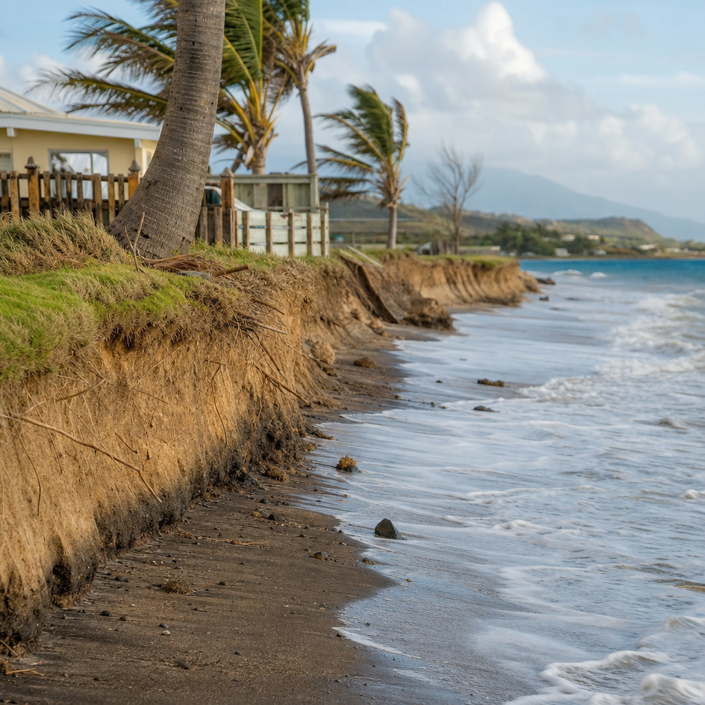
Reading a shoreline well means looking for patterns, not isolated incidents. Warning signs of active erosion include fresh scarps in dunes, exposed roots, fallen trees, narrowing dry beach width, undermined access paths, collapsing backshore edges, and persistent turbidity where waves rework loose sediment. A wider beach after one calm season does not automatically mean the problem is solved. The more reliable indicators are multi-year shoreline position, sediment budget trends, storm recovery rates, and the condition of protective habitats offshore and on land.
For Saint Kitts, the practical lesson is straightforward. Coastal erosion is natural, but its severity depends on how well the island’s sediment system still functions. Protect reefs, seagrass, dunes, and mangroves. Respect setbacks. Monitor beaches consistently with profiles, drone imagery, and historical comparisons. Treat each bay according to its own exposure, geology, and sediment supply. As the Miscellaneous hub under Nature and Wildlife, this page provides the foundation for every related coastal topic on the site. Use it to explore deeper articles on habitats, storms, conservation, and shoreline management, and let that knowledge guide smarter choices at the water’s edge.
Frequently Asked Questions
What is coastal erosion, and why is it happening along parts of Saint Kitts?
Coastal erosion is the gradual or sometimes rapid retreat of the shoreline when more sand, gravel, or soil is removed from a beach or coastal bluff than is naturally replaced. In Saint Kitts, this happens because the coast is shaped by a combination of natural forces working together over time rather than by one single cause. Waves break on the shore and move sediment up and down the beach. Currents transport sand along the coastline from one area to another. Seasonal changes in wind and wave energy can cause beaches to widen during calmer periods and narrow during rougher ones. Storms can accelerate this process by stripping away large amounts of sand in a short time.
On top of that, sea level change can make it easier for waves to reach farther inland, increasing the likelihood of shoreline retreat. The amount of sediment delivered from rivers and upland areas also matters, because beaches need a regular supply of material to maintain themselves. If that supply is reduced, erosion can become more noticeable. Offshore coral reefs and nearshore habitats help absorb wave energy, so when reef condition declines, the shoreline may become more exposed. In Saint Kitts, where beaches are central to tourism, fishing access, wildlife habitat, and everyday community use, erosion is best understood as a dynamic island process shaped by the interaction of ocean energy, sediment movement, storms, and coastal land use.
How do waves, currents, and storms work together to reshape beaches in Saint Kitts?
Waves, currents, and storms are the main physical drivers that constantly remodel the shoreline. Under normal conditions, waves carry sand onto the beach and pull some of it back offshore, creating an ongoing exchange that may not be obvious from day to day. At the same time, currents generated by waves and tides move sediment along the coast in what is often called longshore transport. This means that sand eroded from one section of beach is not necessarily lost forever; it may simply be shifted to another location. Whether a beach grows or shrinks depends on the balance between incoming and outgoing sediment.
Storms change that balance dramatically. Powerful storm waves can cut into the upper beach, carve scarps, wash sand offshore, and damage dunes or vegetation that would normally help stabilize the coast. In Saint Kitts, tropical systems and heavy weather events can produce sudden episodes of erosion that appear alarming, even if part of that sand later returns during calmer months. However, if repeated storms occur close together, or if the natural recovery period is disrupted, the beach may not rebuild fully. Over time, these repeated losses can produce a net retreat of the shoreline. Understanding this cycle is important because a beach that looks stable in one season may be highly mobile over several years, especially on an island exposed to changing weather patterns and open-ocean wave energy.
What roles do sea level change, river sediment, and coral reefs play in coastal erosion?
Sea level change, sediment supply, and reef condition are three major background factors that influence how vulnerable a coastline is to erosion. As sea level rises or fluctuates over long periods, the shoreline often adjusts landward because waves are able to reach higher parts of the beach more often. Even a gradual rise can increase the frequency of wave attack on areas that were once reached only during storms or unusually high tides. This does not mean every section of coast erodes at the same rate, but it does mean low-lying and sandy shorelines can become more sensitive to wave energy over time.
River sediment is equally important because beaches depend on a source of sand and other material. Streams and rivers can deliver sediment from inland slopes to the coast, where it becomes part of the beach system. If less material reaches the shoreline due to changes in drainage, trapping upstream, or other interruptions, the beach may lose more sediment than it gains. Coral reefs add another layer of protection by reducing wave force before it reaches shore. Healthy reefs and nearshore marine habitats act as natural buffers, helping to calm the water and protect sandy beaches. When reef structure is weakened, wave energy can pass more directly toward the coast, increasing the potential for erosion. In Saint Kitts, these processes are deeply connected, which is why effective shoreline understanding must look beyond the visible beach and include the wider land-sea system.
Can human activity make natural coastal erosion worse in Saint Kitts?
Yes, human activity can intensify erosion even when the underlying process is natural. Coastal erosion is a normal part of shoreline change, but development decisions can make beaches less able to absorb and recover from wave action. Buildings, seawalls, roads, and other hard infrastructure placed too close to the shore can interfere with the natural movement of sand and the inland migration of beaches. In some cases, structures that are meant to protect property may reflect wave energy back onto the beach, causing sand to be scoured away faster. Clearing vegetation, damaging dunes, or repeatedly disturbing the upper beach can also reduce natural stability.
Beach use matters as well. Heavy foot traffic, vehicle access, poorly planned construction, and unregulated shoreline modification can weaken the features that help a beach recover after storms. Activities that affect coral reefs, nearshore ecosystems, or sediment pathways can also have downstream effects on erosion. For Saint Kitts, this is especially significant because beaches serve many purposes at once: they support tourism businesses, provide access for fishers, create nesting habitat for sea turtles, and offer public recreational space. When planning does not account for how beaches naturally shift over time, short-term convenience can create long-term shoreline problems. The most effective approach is not to treat erosion as something that can always be stopped everywhere, but to manage coastal use in ways that work with natural processes rather than against them.
Why is understanding coastal erosion important for tourism, communities, and long-term planning in Saint Kitts?
Understanding coastal erosion is essential because beaches in Saint Kitts are not just scenic landscapes; they are working natural systems that support the island’s economy, ecology, and daily life. For tourism, beach width, appearance, and accessibility strongly influence visitor experience and the value of coastal properties. For local communities, beaches provide places for recreation, shoreline access, cultural connection, and in some areas support for fishing activity. For wildlife, especially nesting sea turtles, the shape and stability of the shore can determine whether suitable habitat remains available. When erosion is misunderstood, decisions may be made that protect one small area temporarily while creating bigger problems nearby.
Long-term planning depends on recognizing that shorelines move. A beach that appears wide and secure today may shift after a series of storms, changes in wave direction, or reduced sediment supply. This is why coastal management must be based on observation, monitoring, and an understanding of how natural systems behave over time. In Saint Kitts, that means looking carefully at erosion hotspots, seasonal beach changes, reef health, development setbacks, and the needs of both people and ecosystems. Better understanding leads to better choices about where to build, how to protect infrastructure, when to restore natural buffers, and how to preserve public and environmental benefits. In practical terms, knowledge of coastal erosion helps the island reduce risk, protect livelihoods, and make smarter decisions for a changing shoreline future.