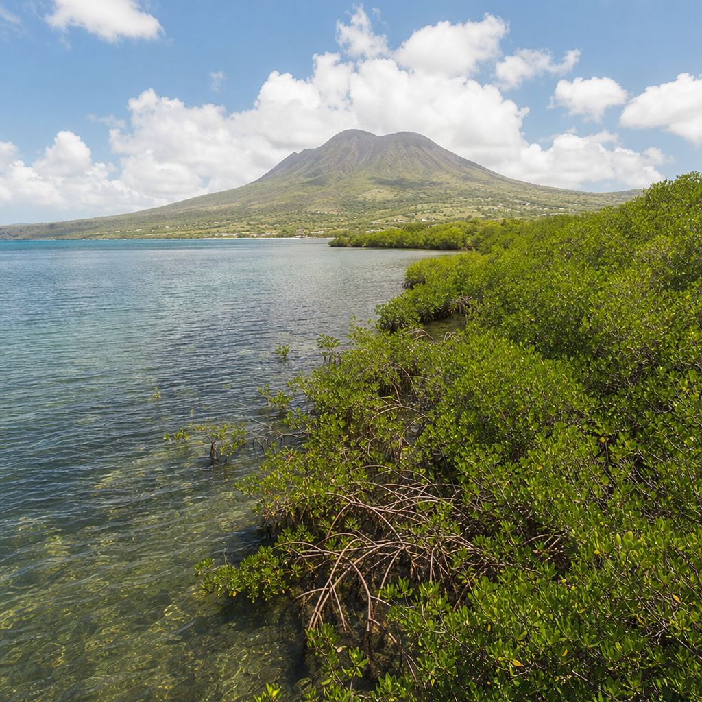
The mangroves of Nevis form one of the island’s most important natural defenses, creating a living barrier between land and sea while supporting fisheries, birds, and coastal communities. On a small Caribbean island where beaches, reefs, salt ponds, and hillside watersheds connect tightly, mangroves are not a fringe habitat; they are infrastructure built by nature. In Nevis, these coastal forests occupy sheltered bays, pond margins, and low-lying shorelines, especially where calm water allows salt-tolerant trees to root in mud and trap sediment. Their value reaches far beyond scenery. Mangroves reduce wave energy, stabilize coastlines, filter runoff, store large amounts of carbon in waterlogged soils, and provide nursery habitat for juvenile fish, crabs, and shrimp that later move to seagrass beds and coral reefs.
When people describe mangroves as green barriers, they mean both a physical and ecological shield. The physical barrier comes from dense above-ground roots, trunks, and branches that slow currents and weaken storm surge. The ecological barrier comes from the way mangroves intercept pollutants, support biodiversity, and create a buffer that helps nearby ecosystems survive stress. On Nevis, where tourism, fishing, waterfront development, and climate risk all shape the coastline, understanding mangroves is essential to understanding the island itself. I have spent years working on coastal content and field-based environmental interpretation in the Caribbean, and mangroves are consistently the habitat visitors underestimate until they see how many species and shoreline functions depend on them.
This hub article covers the mangroves of Nevis comprehensively, serving as a starting point for deeper reading across the broader Nature and Wildlife topic. It explains what mangroves are, where they are found on the island, why they matter to wildlife and people, what threatens them, and how responsible visitors can explore them without causing damage. It also places Nevis in a wider regional context. Across the Caribbean, mangrove loss has been linked to dredging, road building, landfill, polluted runoff, and poorly planned coastal construction. At the same time, restoration and protection efforts increasingly recognize that replacing a mangrove forest is far harder than preserving an intact one. For Nevis, that lesson is practical, not abstract: every healthy mangrove stand helps defend the island’s coasts, fisheries, and natural identity.
What mangroves are and how they function on Nevis
Mangroves are salt-tolerant trees and shrubs adapted to tropical and subtropical coasts where seawater, freshwater, and sediment interact. In the Caribbean, the best-known species are red mangrove, black mangrove, white mangrove, and buttonwood, though buttonwood is often treated as a mangrove associate rather than a true mangrove. Each occupies a slightly different zone. Red mangroves usually grow closest to open water, recognized by arching prop roots that anchor them in soft substrate. Black mangroves often stand slightly inland and can tolerate higher salinity in drier soils; they are identifiable by pencil-like breathing roots called pneumatophores. White mangroves generally occupy higher ground behind them, while buttonwood may appear on the landward edge.
On Nevis, mangrove systems work because they connect habitats rather than operate alone. Sediment washing down from upland slopes can be trapped by roots before it reaches reefs. Organic matter from fallen leaves feeds detritus-based food webs, supporting worms, crabs, juvenile fish, and microorganisms. The forest then acts as a nursery. Many reef fish spend their early life stages in sheltered mangrove channels before moving offshore. That movement matters to local fisheries and to reef resilience. Scientific studies across the wider Caribbean have repeatedly shown that reefs near healthy mangrove and seagrass systems often support greater fish abundance, especially for commercially and ecologically important species.
Mangroves also store carbon exceptionally well. Unlike many terrestrial forests, they lock carbon not just in wood but in deep, oxygen-poor soils where decomposition is slow. This makes them significant long-term carbon sinks despite their relatively small footprint. Just as important for Nevis, they reduce coastal erosion. Root networks bind sediment, and vegetation roughness slows water flow, allowing suspended material to settle. During storms, that friction can lower destructive wave force. Mangroves are not a perfect wall, and they cannot eliminate hurricane damage, but they measurably reduce impact when intact and wide enough. For low-lying coasts, that reduction can make the difference between limited flooding and severe shoreline loss.
Where mangroves fit into Nevis’s coastal landscape
Nevis has a varied coastline of sandy beaches, rocky stretches, salt ponds, nearshore reefs, and developed waterfronts, all shaped by the island’s volcanic topography and marine exposure. Mangroves tend to establish in quieter environments such as lagoon edges, embayments, and pond margins rather than on exposed surf beaches. They are especially associated with areas where fine sediment can accumulate and where salinity fluctuates with rainfall, evaporation, and tidal exchange. This means they are often linked to wetland mosaics rather than standing as isolated forests. On a map, that can make their footprint seem modest; on the ground, their ecological influence is much larger.
For residents and repeat visitors, mangroves are part of a broader chain that includes ghauts, ponds, seagrass beds, and coral reefs. Rain falling on the slopes of Nevis Peak eventually moves through channels and groundwater pathways toward the coast. If upland clearing or construction increases runoff, mangroves are among the last natural filters before material reaches marine habitat. Their condition therefore reflects decisions made inland as much as along the shore. This is one reason environmental planning on islands cannot separate watershed management from coastal conservation. A healthy mangrove stand may look local, but its success is tied to the entire drainage system behind it.
Because this article functions as a hub under Miscellaneous within Nature and Wildlife, it is helpful to see mangroves as a bridge topic. They connect birdwatching with marine ecology, conservation policy with visitor experience, and botanical interest with climate adaptation. A traveler may arrive looking for beaches and leave remembering egrets lifting from a pond edge, juvenile fish darting through roots, or the earthy sulfur-and-salt smell of tidal mud that signals a productive wetland. That is the role of a hub page: to frame mangroves not as a niche subject but as an organizing feature of Nevis’s living coastline.
Wildlife supported by Nevis mangroves
The wildlife value of mangroves is easiest to understand by following the food web from the ground up. Fallen leaves break down into detritus, which feeds microbes and small invertebrates. Those invertebrates feed juvenile fish and crustaceans. Larger fish, wading birds, and predatory species then feed on them. On Nevis, this chain supports both resident and migratory wildlife. Herons, egrets, sandpipers, and other shore-associated birds use wetland edges for feeding and roosting. Crabs shelter in burrows and root tangles. Small fish use shallow, structured water to avoid predators. Insects, mollusks, and worms thrive in nutrient-rich mud.
The nursery function is especially important. Species that adults are seen catching offshore may begin life in protected inshore habitat. In practice, that means a mangrove stand can influence fish stocks beyond its visible boundary. Caribbean research frequently points to higher juvenile survival in structured coastal habitats than on open shorelines. Seagrass and mangroves are often linked in this process: young fish move between the two, then later recruit to reefs. Remove one habitat, and the entire chain weakens. That is why conservation assessments increasingly evaluate habitat connectivity rather than counting species in isolation.
| Habitat role | How mangroves provide it | Typical Nevis relevance |
|---|---|---|
| Nursery shelter | Prop roots and shallow water reduce predator access | Supports juvenile fish and small crustaceans near shore |
| Bird feeding grounds | Mudflats and tidal pools concentrate invertebrates | Useful for herons, egrets, and migratory shorebirds |
| Water filtration | Roots trap sediment and slow runoff | Helps protect seagrass beds and reefs from turbidity |
| Coastal stabilization | Root mats bind soft shoreline soils | Reduces erosion around ponds and sheltered bays |
| Carbon storage | Organic-rich soils hold carbon for long periods | Adds climate value beyond visible tree cover |
Birdlife often gives visitors their most immediate mangrove encounter. Early morning and late afternoon are productive times because light is softer, temperatures are lower, and feeding activity increases. A pair of yellow-crowned night herons or a hunting green heron can reveal how much prey a wetland supports. Even where species counts seem modest compared with larger Caribbean wetlands, the habitat remains disproportionately valuable on a small island. Limited wetland area means every functioning site carries more ecological weight. For that reason, even fragmented mangrove patches on Nevis deserve attention, especially where they contribute to a larger wetland complex.
Threats, tradeoffs, and conservation priorities
The main threats to mangroves on islands like Nevis are well known: coastal development, land reclamation, altered drainage, pollution, trampling, and climate pressure. Development often causes the greatest long-term loss because mangroves occupy flat, accessible land attractive for roads, marinas, housing, and resort infrastructure. Once hydrology is altered by fill, seawalls, culverts, or dredging, the forest may decline even if some trees remain standing for a time. Mangroves are not simply trees beside water; they are a hydrological system dependent on tidal exchange, sediment balance, and salinity patterns. Disrupt those processes, and dieback follows.
Pollution is another serious concern. Nutrient-rich runoff from fertilizers and wastewater can alter water chemistry, while sediment pulses from construction and poorly controlled earthworks can bury roots or cloud adjacent marine habitat. Plastics and other debris accumulate easily in root systems. Small islands also face an enforcement challenge: environmental damage can happen incrementally, through repeated clearing, dumping, or informal foot access, rather than through a single dramatic event. By the time loss is obvious, the ecological function may already be reduced.
Climate change adds complexity rather than a single outcome. Sea-level rise can allow mangroves to migrate inland if space exists, but where roads, walls, or development block that movement, the habitat can be squeezed between rising water and fixed infrastructure. Stronger storms may damage forests directly, yet healthy mangroves also help coasts recover by trapping sediment after disturbance. Conservation therefore depends on both protection and room to adapt. In practical terms, Nevis benefits most from policies that preserve undeveloped wetland margins, maintain water flow, control runoff, and treat mangroves as part of essential coastal resilience infrastructure. Restoration can help in selected sites, especially where hydrology can be reconnected, but mature mangrove systems are slow to replace. Protection remains the highest-return strategy.
How to explore Nevis mangroves responsibly
For visitors, mangroves are best explored with patience and low impact. The first rule is simple: avoid entering sensitive areas unless there is a clear path, boardwalk, or guide-led route designed for access. Mangrove soils compact easily, roots are vulnerable to breakage, and birds may abandon feeding or nesting sites if repeatedly disturbed. Good viewing often requires no entry at all. Binoculars, a camera with moderate zoom, and a willingness to stand quietly at the wetland edge can reveal fish movement, crab activity, and bird behavior within minutes.
Timing matters. Go near sunrise or late afternoon for better wildlife activity and softer heat. Wear closed shoes if conditions are muddy, carry water, and use insect protection where appropriate. If kayaking or paddleboarding near sheltered coastal wetlands, keep a wide distance from root edges and avoid scraping through shallow nursery zones. Do not collect shells, seedlings, or crabs. Do not leave litter, and never assume a quiet pond edge is ecologically empty. Some of the richest habitat looks still until you stop moving and watch.
Responsible exploration also means asking good questions. Is the site connected to a pond or ghaut? Are there signs of erosion, plastic accumulation, or blocked water flow? Are birds using the area for feeding or roosting? These observations deepen the experience and align with how conservationists assess habitat quality in the field. As a hub page within Nature and Wildlife, this article should send readers toward related topics such as Nevis birdwatching, coastal wetlands, marine nursery habitats, and island conservation challenges. The more those subjects are understood together, the clearer the role of mangroves becomes.
The mangroves of Nevis are far more than a strip of coastal greenery. They are nursery grounds, storm buffers, sediment traps, carbon stores, and wildlife habitat bound into the island’s wider system of ponds, reefs, seagrass beds, and upland watersheds. They matter because they protect both biodiversity and human settlement, and because on a small island every surviving wetland carries outsized ecological value. Understanding them changes how Nevis is seen: not just as a beach destination, but as a place where the health of the shoreline depends on living coastal infrastructure.
The central lesson is straightforward. Healthy mangroves work best when they remain connected to natural water flow, buffered from destructive development, and respected by visitors. Their benefits are measurable, from reduced erosion to stronger fish nursery function, yet those benefits can decline quickly when hydrology is altered or habitat is fragmented. That balance of value and vulnerability is exactly why mangroves deserve attention within any serious guide to Nevis nature and wildlife.
If you are exploring the island, make mangroves part of your itinerary and part of your understanding of Nevis. Visit wetland edges carefully, support conservation-minded operators and accommodations, and continue through related Nature and Wildlife articles to build a fuller picture of how the island’s ecosystems connect.
Frequently Asked Questions
Why are mangroves so important to Nevis?
Mangroves are essential to Nevis because they function as one of the island’s most effective natural defense systems. These coastal forests sit at the meeting point of land and sea, where their dense roots slow waves, trap sediment, and reduce shoreline erosion. On a small island like Nevis, where beaches, salt ponds, reefs, and upland watersheds are closely connected, that role is especially important. Mangroves help stabilize fragile shorelines that might otherwise wash away during storms, heavy rainfall, or seasonal sea surges. In practical terms, they act like living infrastructure, buffering coastal communities and ecosystems from damage while continuously rebuilding and reinforcing the coast over time.
Beyond shoreline protection, mangroves support biodiversity and local livelihoods. Their tangled root systems create nursery habitat for juvenile fish, crabs, and other marine species that later populate nearshore waters and reefs. Birds also rely on mangrove areas for nesting, feeding, and shelter, especially around calm bays and pond margins. Because fisheries, birdlife, water quality, and coastal resilience all depend on healthy mangrove systems, these forests are far more than isolated patches of vegetation. They are a central part of how Nevis’s coastal environment works and how the island protects itself naturally.
Where are mangroves typically found on Nevis?
On Nevis, mangroves are usually found in sheltered coastal settings where wave energy is low and sediment can accumulate. This includes quiet bays, low-lying shorelines, salt pond edges, lagoon-like inlets, and areas where freshwater runoff from the hills meets calmer seawater. These locations create the brackish, nutrient-rich conditions mangroves need to establish and grow. Unlike exposed coasts where strong surf can prevent young plants from taking root, these protected zones allow mangrove seedlings to anchor, spread, and gradually build dense coastal stands.
Their placement on the island is not random. Mangroves tend to thrive where multiple natural systems overlap: inland drainage channels carry sediment and organic matter downslope, coastal ponds hold and exchange water, and nearby reefs reduce wave force offshore. This connected geography helps explain why mangroves are so important on Nevis. They occupy strategic transition zones within the island’s broader environmental network, linking upland watersheds to marine habitats. In these places, mangroves help regulate water movement, filter runoff before it reaches the sea, and strengthen the ecological health of the entire coastline.
How do mangroves protect coastlines during storms and flooding?
Mangroves protect coastlines by physically reducing the energy of moving water. Their trunks, branches, and especially their complex above-ground root systems interrupt waves and slow storm surge as it pushes inland. Instead of water striking the shore at full force, the mangrove forest spreads that energy out across a living barrier. This process can reduce erosion, limit the loss of beach and soil, and decrease the amount of floodwater reaching inland areas. On an island such as Nevis, where storms can affect both human communities and sensitive coastal habitats, that protective function is extremely valuable.
Mangroves also help after storms, not just during them. Their roots trap sediment carried by floodwaters and tides, helping rebuild and stabilize the shoreline rather than allowing it to collapse or retreat. They improve drainage patterns, hold soils in place, and reduce the long-term damage caused by repeated weather events. While mangroves are not a complete substitute for engineered coastal defenses in every situation, they often outperform hard infrastructure in flexibility and long-term ecological value. They adapt, grow, and regenerate, making them one of the most cost-effective and resilient forms of natural coastal protection available to islands like Nevis.
What wildlife depends on Nevis’s mangrove ecosystems?
A remarkable range of wildlife depends on mangroves in and around Nevis. Fish and crustaceans are among the most important users of these habitats, especially during their juvenile stages. The sheltered waters among mangrove roots provide protection from predators, abundant food, and calmer conditions than open coastal areas. Many species that later support local fisheries begin life in these shallow nursery grounds. Without healthy mangroves, the productivity of nearby seagrass beds, reefs, and fishing areas can decline because the early life stages of many marine animals become far more vulnerable.
Birds also benefit significantly from mangrove ecosystems. Wading birds, shorebirds, and resident coastal species use mangroves for feeding, roosting, and nesting. Insect life, small aquatic organisms, and tidal flows create a rich food web that supports both resident and migratory birds. In addition, mangroves provide habitat for reptiles, invertebrates, and microorganisms that help break down organic matter and recycle nutrients. What makes mangroves especially valuable is that they do not serve just one species or one layer of the ecosystem. They support an entire web of life that connects the shoreline, ponds, nearshore sea, and offshore reef environments into a single functioning system.
What are the main threats to mangroves on Nevis, and how can they be protected?
The main threats to mangroves on Nevis are the same pressures affecting coastal ecosystems throughout the Caribbean: land development, pollution, altered drainage, sediment imbalance, and climate-related stress. When shorelines are cleared, filled, or modified for construction, mangroves can be fragmented or removed entirely. Runoff carrying sewage, chemicals, plastics, or excess sediment can degrade water quality and disrupt the delicate balance of salinity and oxygen that mangroves require. Even changes farther inland matter. If watershed runoff is poorly managed, the coastal zones where mangroves grow may receive too much sediment too quickly, or not enough freshwater at the right times, weakening the system over time.
Protection starts with recognizing mangroves as critical infrastructure rather than expendable coastal vegetation. Effective conservation includes limiting destructive clearing, enforcing shoreline setbacks, improving wastewater and stormwater management, and protecting the natural flow between hillsides, ponds, and the sea. Community awareness is also important, because local support often determines whether mangroves are valued, monitored, and defended. Restoration can help in damaged areas, but preserving intact mangroves is usually more effective than trying to recreate them after loss. For Nevis, long-term resilience will depend on integrating mangrove protection into broader coastal planning, climate adaptation, and environmental management so these green barriers can continue protecting the island for generations.