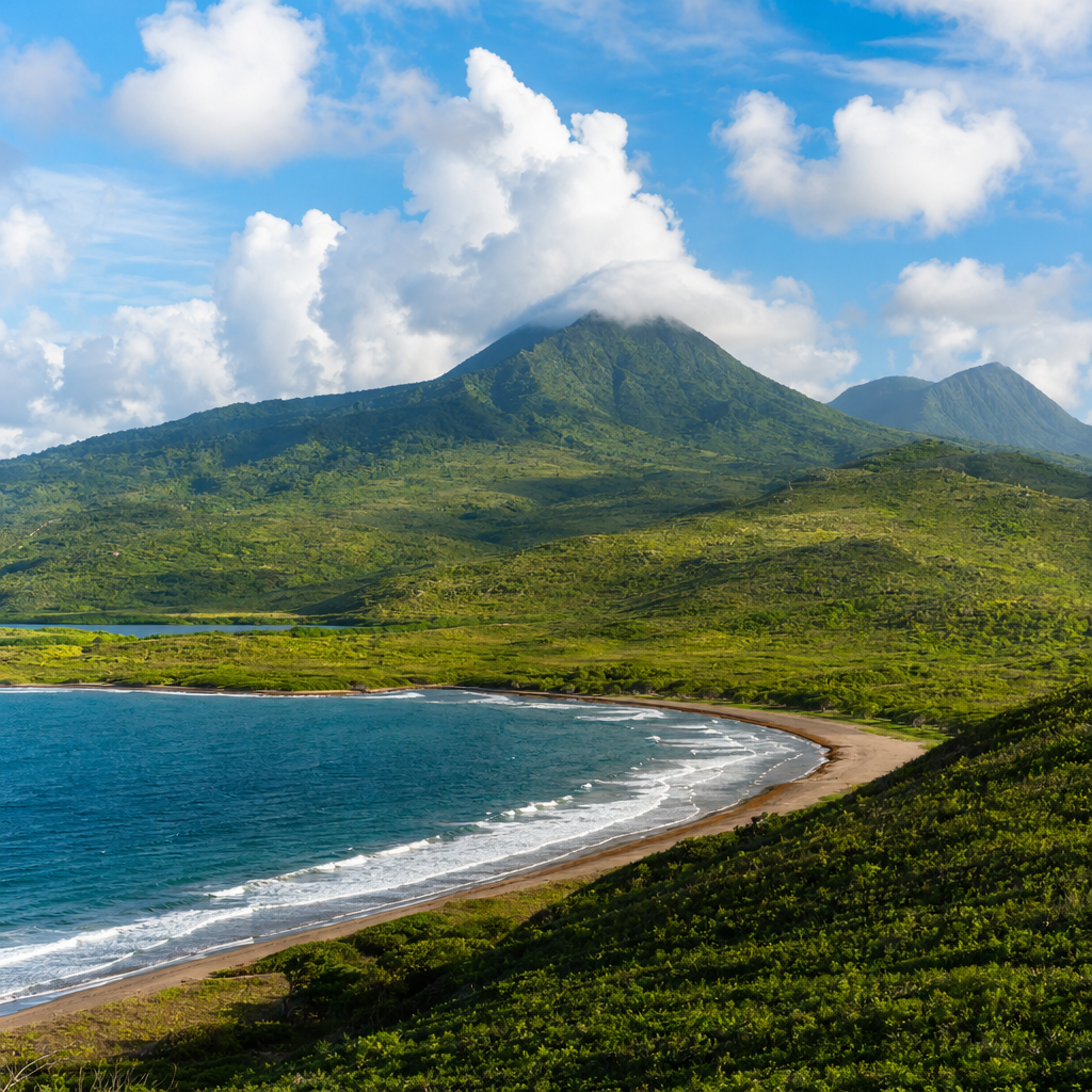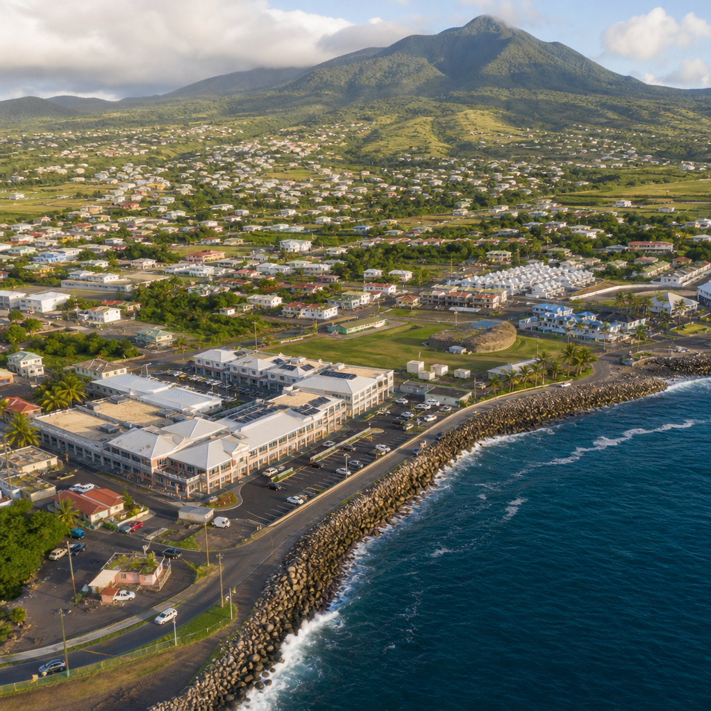
Nevis’ landscape is changing in visible, measurable ways as new roads, housing, tourism projects, retail centers, and public facilities reshape how people live on the island. Urbanization in Nevis does not look like the explosive high-rise growth seen in large Caribbean capitals, yet its effects are just as important because the island is small, ecologically sensitive, and deeply tied to agriculture, village life, and coastal ecosystems. In practical terms, urbanization means the expansion and intensification of built environments: more land converted to homes and businesses, more infrastructure serving concentrated populations, and more economic activity organized around services rather than farming or fishing. On Nevis, that process intersects with limited land supply, heritage settlements, hurricane exposure, water management, and the demands of a tourism-led economy.
Anyone trying to understand local life and experiences in Nevis needs this broader view. Housing availability affects whether young families stay on island. Road improvements change commuting patterns between Charlestown, Gingerland, and expanding residential areas. New visitor accommodations can create jobs while also increasing pressure on beaches, utilities, and property prices. I have worked on island-focused content and regional development analysis long enough to know that the most useful discussion is neither nostalgic nor boosterish. Urbanization brings genuine gains: better services, improved connectivity, stronger public revenue potential, and more diverse business opportunities. It also creates tradeoffs that residents feel immediately, from traffic at key junctions to concerns about drainage, visual character, and access to open land.
This article serves as a hub for the miscellaneous side of local life in Nevis by connecting the main issues that shape daily experience. It explains where urbanization is happening, why it matters, and how it influences environment, culture, infrastructure, jobs, and community identity. It also provides clear framing for related topics, including housing, transportation, tourism development, land use, public services, and conservation. If you want one page that organizes the big picture of Nevis’ changing landscape in plain terms, this is it.
What Urbanization Looks Like on Nevis
Urbanization on Nevis is best understood as a pattern of spreading nodes rather than one dominant city swallowing the countryside. Charlestown remains the administrative and commercial center, with government offices, schools, shops, ferry connections, and health services drawing regular movement. Around that core, development extends along road corridors and into villages where formerly low-density plots are increasingly subdivided for homes, apartments, guesthouses, and small commercial uses. This is a common small-island pattern: growth follows transport routes, utility access, and areas already attractive to investors and returning nationals.
Several drivers push this change. Tourism remains central, especially higher-end villa development, boutique accommodation, and supporting businesses such as restaurants, transportation services, landscaping, and property management. Population shifts also matter. Even when total population growth is modest, household formation can still raise demand for housing because more people want separate homes, modern amenities, and proximity to work or school. Diaspora investment adds another layer, often improving housing stock but sometimes raising land values faster than local wages. Public investment in roads, ports, utilities, and communications can then accelerate private construction by making previously underused areas easier to access.
The result is not uniform urban growth. Some places experience infill, where vacant lots inside settled areas are built on. Others see edge expansion, where homes and commercial buildings move outward into former agricultural or open lands. Coastal development is especially sensitive because scenic and accessible sites attract investment first. In Nevis, that means urbanization is as much about land-use intensity as pure population concentration. A hillside road with scattered houses, a cluster of vacation villas, and a roadside strip of mixed-use buildings can all represent urbanization even without dense skyline development.
Economic Growth, Jobs, and Rising Land Values
The strongest argument in favor of urbanization is economic opportunity. Construction activity creates immediate demand for contractors, masons, electricians, plumbers, surveyors, equipment operators, and suppliers. Once projects open, they support long-term jobs in hospitality, maintenance, retail, administration, and transport. On small islands, these multiplier effects matter because a single development can affect taxi drivers, farmers supplying produce, laundry services, internet providers, and artisans selling to visitors. Well-planned urban growth can therefore widen the local economic base beyond traditional sectors.
Property markets also respond quickly. Land near main roads, beaches, and commercial centers usually gains value when infrastructure improves or visitor demand increases. For homeowners, that can build wealth and create borrowing power. For governments, higher assessed values can strengthen the tax base that funds public services. The problem is affordability. When land values and rents rise faster than incomes, younger residents, public workers, and service-sector employees can struggle to buy or lease homes near employment centers. I have seen this pattern repeatedly across island economies: the same development that expands jobs can make it harder for those workers to live close to work.
The balance depends on policy and timing. If authorities map growth areas, reserve land for local housing, and align infrastructure with realistic demand, urbanization can improve prosperity without fully displacing residents. If development runs mostly through ad hoc approvals, speculative pricing often wins. Nevis has an advantage here because its scale makes planning more visible. Residents know when farmland is being converted, when road traffic is worsening, and when neighborhoods are changing. That local awareness can support better decisions if it is matched with transparent planning standards and reliable enforcement.
| Urbanization Driver | Main Benefit | Primary Risk | Visible Example in Nevis Context |
|---|---|---|---|
| Tourism development | Jobs and foreign exchange | Coastal pressure and higher land prices | New villas or boutique stays near scenic shorelines |
| Road and utility upgrades | Better access and service delivery | Faster sprawl into open land | More homebuilding along improved transport corridors |
| Housing demand | Modern accommodation for residents | Loss of agricultural parcels | Subdivision of larger family-owned plots |
| Commercial expansion | Convenience and local business growth | Traffic and parking strain | Mixed-use roadside clusters near Charlestown approaches |
Infrastructure Pressure: Roads, Water, Waste, and Energy
Urbanization succeeds or fails on infrastructure. Roads are usually the first stress point people notice. More homes, rental cars, service vehicles, and delivery traffic increase congestion at intersections and near schools, ferry terminals, and commercial strips. On Nevis, where road widths and alignments are constrained by topography and historic settlement patterns, a modest rise in vehicle numbers can have an outsized effect. Better paving improves mobility, but it can also encourage faster buildout unless drainage, sidewalks, parking management, and road safety are upgraded at the same time.
Water systems face an even harder test. Small islands must manage seasonal variability, storage capacity, pipe losses, and competing demand from households, hotels, landscaping, and agriculture. Urban growth raises peak demand, especially in dry periods. If new developments are approved without clear water availability assessments, shortages become more likely. The same logic applies to wastewater and stormwater. More roofs, paved surfaces, and compacted land reduce natural absorption, increasing runoff and flood risk. Proper culverts, retention measures, setbacks, and maintenance are not optional technical details; they are the difference between a resilient neighborhood and a recurring drainage problem.
Solid waste and energy also change with urbanization. Denser settlement produces more household waste, construction debris, and commercial refuse that must be collected and managed reliably. Energy demand rises as more buildings use air-conditioning, refrigeration, lighting, and digital systems. For Nevis, this creates both risk and opportunity. Greater demand can strain existing systems, but it can also justify investment in distributed solar, efficiency standards, and smarter utility planning. The key principle is sequencing. Infrastructure should lead or at least keep pace with development, not chase it years later at higher cost.
Environmental Effects on Coastlines, Slopes, and Biodiversity
Because Nevis is compact and environmentally diverse, land-use changes quickly affect natural systems. Coastal zones are especially vulnerable. Building too close to shore can accelerate erosion, disrupt dune processes, fragment habitat, and increase exposure to storm surge. Even where structures are elevated and attractively designed, cumulative impacts matter. More access roads, seawalls, landscaping, and septic loads can degrade beaches and nearshore waters over time. That is significant not only for wildlife but also for tourism itself, since clean beaches and healthy marine environments are among the island’s core assets.
Interior hillsides and former agricultural lands face different pressures. Clearing vegetation for houses or roads can increase runoff and sediment movement, particularly during intense rainfall. On steep terrain, poor site preparation raises the risk of slope instability. Biodiversity loss may seem gradual, yet small-island ecosystems can tip quickly when habitat patches are reduced or disconnected. Birds, pollinators, and coastal species all depend on a mosaic of intact spaces. Urbanization does not automatically destroy that mosaic, but it does if planning ignores buffers, tree cover, watershed function, and the carrying capacity of local ecosystems.
Environmental review therefore needs to be practical and place-specific. A sensible approach considers elevation, soil conditions, drainage paths, storm exposure, and ecological value before permits are granted. Setbacks, density limits, permeable surfaces, rainwater harvesting, and native landscaping are proven measures, not abstract ideals. In my experience, the strongest island developments are the ones that respect topography rather than trying to overpower it. On Nevis, preserving natural systems is not anti-development. It is basic economic self-protection because environmental decline is expensive to reverse and easy for residents and visitors to notice.
Culture, Heritage, and the Texture of Daily Life
Urbanization changes more than land cover; it changes how a place feels. Nevis has a distinctive rhythm shaped by village identity, historic architecture, churches, schools, markets, family landholding patterns, and long-standing social networks. As development intensifies, that texture can either be reinforced or diluted. Well-designed projects can restore older buildings, improve public spaces, and keep commercial activity within walkable historic areas. Poorly integrated growth can replace vernacular forms with generic construction, weaken neighborhood cohesion, and make daily life more car-dependent and less communal.
Charlestown illustrates this tension clearly. Historic centers work best when planning protects scale, sightlines, mixed uses, and human movement. If traffic, parking demand, and incompatible building forms overwhelm the town core, heritage value erodes even when individual landmarks remain standing. The same issue appears in villages where new construction outpaces public realm planning. A larger population can support shops and services, but without sidewalks, shade, gathering spaces, and drainage, growth feels fragmented rather than vibrant. Residents then experience urbanization as inconvenience instead of improvement.
There is also a social equity dimension. Longtime residents often worry that development tailored to visitors or affluent buyers will redefine local priorities. Those concerns should not be dismissed as resistance to progress. They are legitimate questions about access, belonging, and continuity. Who can still afford land? Which beaches remain easy to reach? Are traditional events, local foodways, and community meeting places being supported or crowded out? Urbanization is healthiest when it expands options for residents first and captures visitor spending second, not the other way around.
Planning Better Growth for Nevis’ Future
Nevis does not need to choose between preservation and development. It needs disciplined growth management that recognizes the island’s physical limits and social strengths. The most effective tools are straightforward: updated land-use plans, enforceable zoning, hazard mapping, infrastructure capacity studies, coastal setbacks, heritage protection guidelines, and transparent development review. These are standard planning instruments used across resilient island jurisdictions because they reduce conflict and make investment more predictable. Developers benefit when rules are clear, and residents benefit when approvals reflect long-term public interest rather than short-term pressure.
Housing policy deserves special attention. If most new construction targets luxury demand, labor shortages and affordability stress will intensify in essential sectors. A balanced strategy includes serviced lots, modest-density housing near jobs, incentives for local ownership, and building standards suited to climate and maintenance realities. Transport planning should also shift from purely moving cars to improving safe movement for pedestrians, schoolchildren, and older residents. Sidewalks, crossings, drainage, and shaded public areas are not cosmetic additions; they are basic quality-of-life infrastructure in growing communities.
Data should guide every major decision. Building permits, traffic counts, water demand projections, flood maps, shoreline monitoring, and housing price trends reveal whether growth is sustainable. Without current data, debate becomes anecdotal and polarized. With it, officials can phase projects, prioritize upgrades, and explain tradeoffs honestly. Nevis is small enough to act strategically and visible enough that residents can hold institutions accountable. That combination is powerful if used well.
Nevis’ changing landscape tells a larger story about local life: growth brings opportunity, but on a small island every land-use decision carries consequences that are hard to hide and harder to undo. Urbanization can support jobs, better services, stronger infrastructure, and more dynamic communities when it is directed carefully. It can also intensify flooding, affordability problems, ecological stress, and cultural loss when building outruns planning. The difference is not theoretical. It shows up in the condition of roads, the availability of housing, the health of beaches, and the feel of neighborhoods from Charlestown to inland villages.
The clearest takeaway is that urbanization in Nevis should be measured by quality, not just quantity. More buildings do not automatically mean progress. Progress means development that fits the land, protects heritage, expands opportunity for residents, and pays for the infrastructure it requires. For anyone exploring local life and experiences in Nevis, this hub topic connects the practical issues behind daily change: where people live, how they move, what they can afford, and what kind of island they want to pass on. Use this overview as your starting point, then explore related articles on housing, transport, environment, tourism, and community planning to see how each piece shapes Nevis’ future.
Frequently Asked Questions
1. What does urbanization look like in Nevis compared with larger Caribbean islands?
Urbanization in Nevis is more gradual and low-rise than the dramatic skyline growth seen in larger Caribbean capitals, but that does not make it minor. On a small island, even modest expansion can have far-reaching effects. In Nevis, urbanization often appears as the steady extension of roads, the construction of new housing developments, tourism-related buildings, retail spaces, utility upgrades, and public infrastructure such as schools, clinics, and community facilities. Rather than transforming the island with dense towers or massive industrial districts, it changes the landscape incrementally, often village by village and coastline by coastline.
This quieter pattern is important because Nevis has limited land, fragile ecosystems, and a strong cultural connection to agriculture and close-knit communities. A new road can improve access and reduce travel time, but it can also open previously undeveloped land to construction. A hotel or residential project can create jobs and expand economic activity, yet it may also increase pressure on water resources, roads, and coastal environments. In short, urbanization in Nevis is defined less by scale and more by sensitivity: small physical changes can produce large social, environmental, and economic consequences.
2. How is urbanization affecting agriculture and open land in Nevis?
One of the most significant effects of urbanization in Nevis is the gradual conversion of open land to non-agricultural uses. As demand grows for homes, tourism facilities, commercial buildings, and road access, land that might once have supported farming or remained part of the island’s green landscape can become fragmented or permanently developed. This is especially important in a place where agricultural land is limited and where farming has long been tied not only to food production, but also to local identity, landscape character, and rural livelihoods.
The pressure on agricultural space does not always come from a single large project. Often, it happens through a series of smaller changes: subdivision of family land, road improvements that increase land value, scattered housing construction, or infrastructure expansion near existing settlements. Over time, these cumulative changes can reduce the amount of connected farmland available for cultivation and make farming less practical. Farmers may face higher land costs, more competition for water, and conflicts with nearby residential uses.
At the same time, urbanization can create opportunities if managed carefully. Better roads can help farmers move goods more efficiently, and improved services can support agro-processing, local markets, and farm-to-tourism linkages. The key issue is planning. If development takes place without protecting productive land, Nevis risks losing both food security potential and a visible part of its traditional landscape. If it is guided strategically, however, the island can support growth while preserving the agricultural spaces that remain essential to its heritage and resilience.
3. What environmental impacts does urban growth have on a small island like Nevis?
Environmental impacts are especially serious in Nevis because the island’s ecosystems are interconnected and relatively compact. When urban growth increases the amount of paved surfaces, cleared land, and built-up coastal areas, it can affect drainage, soil stability, habitat quality, and water runoff. Development on slopes or in previously vegetated areas may contribute to erosion, while construction near shorelines can place additional stress on beaches, mangroves, reefs, and other coastal systems that help protect the island from storms and sea-level rise.
Another major concern is the effect on freshwater resources and waste management systems. More homes, hotels, restaurants, and public facilities mean greater demand for water and more wastewater to manage. On a small island, those systems have natural and technical limits. If expansion moves faster than infrastructure capacity, the result can be pressure on groundwater, pollution risks, and long-term environmental degradation. Even increases in traffic and energy use can matter, contributing to air pollution, noise, and higher emissions.
That said, urbanization does not automatically mean environmental decline. Smart planning can reduce damage by directing growth away from sensitive habitats, enforcing setbacks and drainage controls, preserving green buffers, and investing in resilient infrastructure. In Nevis, the stakes are high because natural beauty is not just an environmental asset; it is also central to tourism, public health, and the island’s overall quality of life. Protecting ecosystems while accommodating development is therefore not an optional goal, but a practical necessity.
4. How does urbanization change daily life and community character in Nevis?
Urbanization changes daily life in Nevis in ways that people often feel long before they are formally measured. Improved roads, expanded services, and new commercial areas can make life more convenient by shortening travel times, increasing access to healthcare and education, and broadening shopping and employment options. For many residents, these are meaningful benefits that can improve living standards and create a stronger sense of opportunity, especially for younger people seeking work outside traditional sectors.
At the same time, growth can alter the social fabric of villages and long-established neighborhoods. As land use changes, communities that were once defined by farming, shared open space, and close personal ties may become more mixed in character or more commercially oriented. Property values may rise, which can benefit some landowners but also make housing less affordable for others. Increased traffic, denser settlement patterns, and the arrival of new businesses can shift the pace and feel of everyday life.
There is also a cultural dimension. In Nevis, landscape and identity are closely linked. Changes to village layouts, historic areas, and traditional land use can affect how people relate to place and to one another. This does not mean development should be resisted outright. It means that planning should respect community history, public access, and the scale of local settlements. When urbanization is guided with local input, it can support modern needs without erasing the cultural patterns that make Nevis distinctive.
5. What can Nevis do to manage urbanization in a sustainable way?
Sustainable urbanization in Nevis begins with recognizing that land is limited and every major development choice has long-term consequences. Effective management depends on clear land-use planning, strong environmental review, and a willingness to balance economic growth with ecological protection and community needs. This includes identifying where housing, tourism, commerce, agriculture, and conservation should be prioritized, rather than allowing piecemeal expansion to shape the island by default.
Infrastructure planning is equally important. New development should be matched with realistic capacity for roads, drainage, water supply, wastewater treatment, solid waste management, and energy systems. If growth outpaces infrastructure, the island can face congestion, flooding, service failures, and environmental stress. By contrast, coordinated planning can produce more resilient outcomes and reduce long-term costs. Building standards, zoning rules, hillside and coastal protections, and green space requirements all have a role to play.
Public participation is another essential piece. Residents often have detailed knowledge about flooding patterns, community needs, historical land uses, and environmental vulnerabilities. Including local voices can improve decision-making and build trust around development choices. In practical terms, sustainable urbanization for Nevis means pursuing growth that is measured, place-sensitive, and future-focused. The goal is not to prevent change, but to shape it so the island can expand opportunity while preserving the landscapes, ecosystems, and community character that define Nevis.