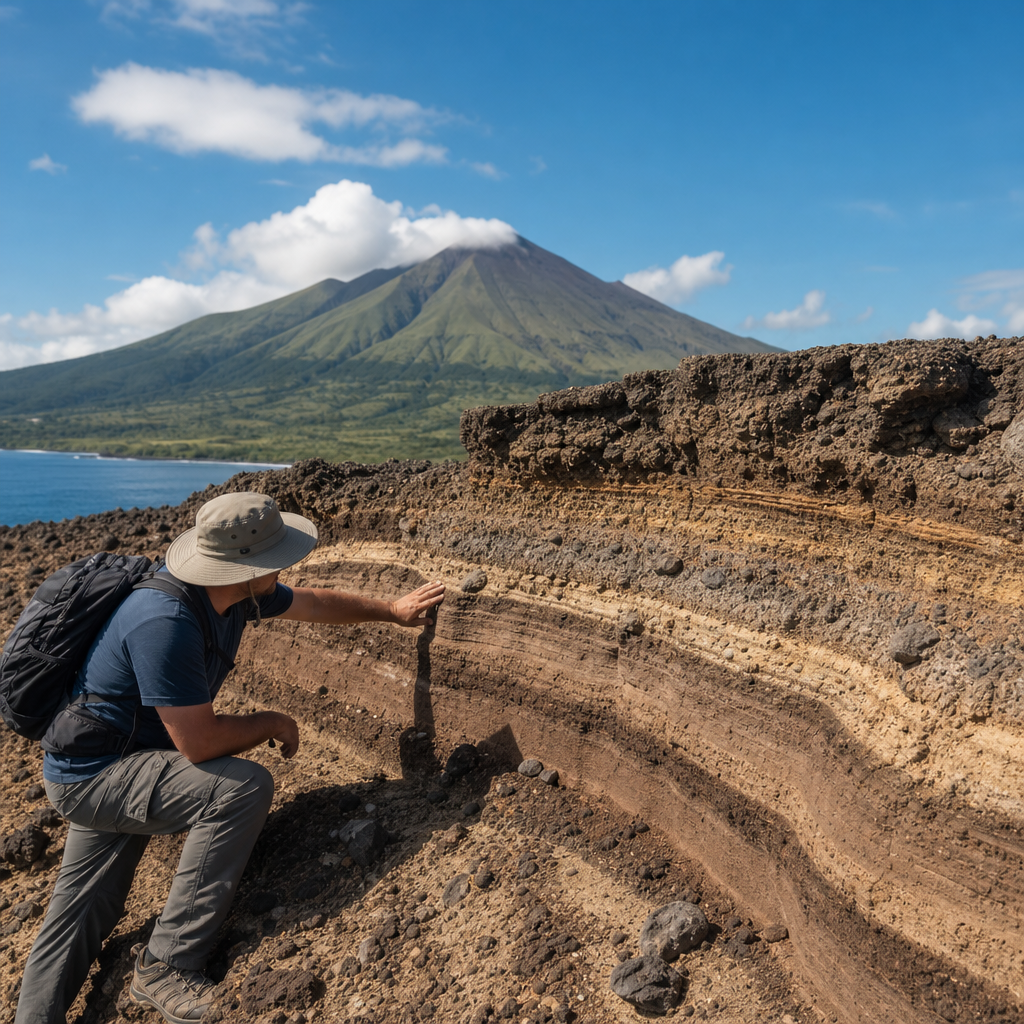
Studying the geology of Nevis reveals how a small Caribbean island can preserve an unusually clear record of volcanic construction, tropical weathering, coastal change, and ongoing environmental risk. In simple terms, the geology of Nevis is the story of how magma rising from deep within the Earth built the island, how ash and lava shaped its slopes, and how rain, heat, reefs, and waves have been reshaping it ever since. Nevis sits in the Lesser Antilles island arc, a curved chain created where the Atlantic plate descends beneath the Caribbean plate, generating magma and feeding a line of volcanoes that includes neighboring St. Kitts, Montserrat, and Dominica. The island’s dominant landform, Nevis Peak, is a stratovolcano, meaning a steep volcanic mountain built from alternating layers of lava, ash, and fragmented debris. Around that volcanic core lie younger sediments, coastal deposits, hot springs, and deeply weathered soils that connect geology directly to farming, biodiversity, settlement patterns, and tourism. I have worked with volcanic island landscapes long enough to know that places like Nevis reward close observation: road cuts, quarry faces, beach ridges, and spring deposits often explain more than any postcard view. For readers interested in nature and wildlife, this matters because geology determines drainage, soil fertility, forest type, shoreline habitat, and hazard exposure. Understanding the island’s formation is therefore not a niche scientific exercise; it is the foundation for interpreting nearly every natural system on Nevis.
Tectonic setting: why Nevis exists at all
The first question most readers ask is straightforward: what created Nevis? The answer is plate subduction. East of the Caribbean, the dense oceanic crust of the Atlantic realm moves westward and sinks beneath the Caribbean Plate along the Lesser Antilles subduction zone. As that slab descends, water released from minerals in the plate lowers the melting point of the overlying mantle, producing magma. That magma rises, pools, evolves chemically, and eventually erupts to form volcanic islands. Nevis is one product of that process. This setting is not speculative; it is established through seismic studies, regional geochemistry, and the alignment of active and extinct volcanic centers across the arc. In practical terms, the island exists because deep Earth processes supplied repeated batches of magma over long periods, allowing a submarine volcano to emerge above sea level and grow into a rugged island.
Nevis is part of the inner volcanic arc rather than a standalone anomaly, and that regional position is important. The island shares many arc-volcano traits: andesitic to dacitic volcanic materials, explosive eruptive phases, hydrothermal alteration, and steep topography focused around a central edifice. Yet it also shows local variation. Compared with larger volcanic islands, Nevis presents a relatively compact and accessible geological system. The mountain, ring plains, coastal shelves, and hot spring zones can be studied within short distances, making it especially valuable as a hub topic for miscellaneous nature and wildlife articles. A hiker, birder, botanist, or coastal ecologist on Nevis is inevitably reading a volcanic landscape, whether noticing cloud forest on upper slopes or black sand mixed with coral fragments on the shore.
The building of Nevis Peak
Nevis Peak, rising to about 985 meters, is the island’s defining geologic structure and the main source of its rocks. As a stratovolcano, it was built by repeated eruptions that deposited lava flows, pyroclastic material, volcanic ash, lahars, and reworked slope debris. A stratovolcano does not grow in one simple upward push. Instead, eruption style changes over time depending on magma composition, gas content, water interaction, vent geometry, and collapse events. On Nevis, geologists interpret the island as a composite volcanic center whose mass accumulated through multiple eruptive episodes, likely including both effusive lava emplacement and more explosive ash-producing activity. The steep radial drainage pattern around the mountain still reflects that cone-building history.
One of the most useful ways to understand the island is to think in layers and processes rather than a single eruption. Lava flows can produce relatively resistant ridges, while pyroclastic deposits weather faster and often form softer slopes or gullied terrain. Debris flows, especially in tropical high-rainfall conditions, can sweep volcanic material downslope and create broad aprons around the mountain. Over time, these volcanic products are cut by streams, altered by groundwater, and buried in places by younger sediments. In the field, that means outcrops on Nevis can shift quickly from blocky lava to oxidized ash-rich material to rounded alluvium. This variability is one reason the island is geologically rich despite its modest size.
Rock types, landforms, and what they tell us
The geology of Nevis is dominated by volcanic rocks and volcaniclastics, but the details matter. Typical island-arc magmas often crystallize as andesite or dacite, rocks that contain minerals such as plagioclase, pyroxene, amphibole, and iron-titanium oxides. In weathered tropical exposures, fresh mineralogy is not always obvious, yet textures still reveal origin. Dense lava may show vesicles from trapped gases, while fragmental deposits contain angular clasts that indicate explosive eruption or slope failure. Hydrothermal fluids can alter original minerals into clays, silica, and iron oxides, changing both color and strength. On Nevis, altered zones deserve attention because they can weaken slopes and influence spring chemistry.
Beyond the volcanic core, the island includes alluvial fans, beach deposits, raised coastal features, and marine sediments. These materials record what happened after eruption. Streams moving off Nevis Peak carry boulders, gravel, sand, and silt to lower ground, where flatter areas support roads, villages, and agriculture. Along the shore, carbonate sands derived from shells and coral mix with volcanic grains, producing beaches that vary noticeably from one bay to another. In some coastal areas, storm ridges and beachrock preserve evidence of changing sea levels and wave energy. These are not minor details. They help explain why some coasts erode quickly, why some soils drain better than others, and why habitat differs over very short distances.
How weather, water, and time reshaped the island
Once a volcanic island emerges, erosion begins immediately. On Nevis, high rainfall on upper slopes, strong tropical downpours, warm temperatures, and dense vegetation have combined for thousands of years to carve the original volcano into its present form. Deep chemical weathering is especially important in humid tropical settings. Water reacts with feldspars and mafic minerals, converting them into clays and iron-rich residues. This process weakens rock, thickens soil, and changes slope stability. In many places, what looks like bedrock is actually saprolite, rock so altered that it can be cut or crumbled much more easily than fresh lava.
Water is also the chief sculptor of Nevis’s drainage. Radial gullies and ghauts descend from the central peak toward the coast, carrying seasonal runoff and sediment. During intense rain, channels that seem inactive can move large loads quickly, which is one reason flood and debris-flow mapping matters for land use. Over geologic time, this drainage network lowers relief, redistributes volcanic debris, and creates fertile lower slopes. I have seen similar systems on other arc islands where one storm cuts a fresh exposure that reveals ash, lahar, and paleosol layers in a single wall. Nevis offers the same kind of readable landscape, especially where roads, stream cuts, or construction expose subsurface material.
Key geologic features of Nevis at a glance
For readers using this page as a hub, the table below summarizes the main features that define the island’s geology and why each matters for broader nature and wildlife study.
| Feature | Geologic meaning | Why it matters today |
|---|---|---|
| Nevis Peak | Composite volcanic cone formed by repeated eruptions | Controls elevation, rainfall, forest zones, and drainage |
| Volcaniclastic slopes | Ash, lapilli, debris-flow, and reworked volcanic deposits | Influence soil fertility, erosion rates, and slope stability |
| Hot springs | Evidence of persistent geothermal circulation | Supports tourism and indicates ongoing subsurface heat |
| Alluvial fans and lowlands | Sediment spread outward from mountain channels | Host farms, roads, and many settled areas |
| Mixed volcanic-carbonate beaches | Shoreline deposits from both land erosion and marine life | Shape coastal habitat, recreation, and erosion vulnerability |
| Weathered tropical soils | Products of long-term chemical alteration of volcanic rock | Support vegetation but can be fragile under disturbance |
Hot springs, hydrothermal activity, and geothermal clues
One of the most distinctive aspects of Nevis geology is the presence of hot springs, especially around Bath village, long known for thermal waters. Hot springs form when groundwater circulates downward through fractures, heats at depth in a still-warm volcanic system, and rises back to the surface carrying dissolved minerals. Their existence does not mean an eruption is imminent, but it does confirm that Nevis is not merely an inert pile of old lava. Residual heat, permeability pathways, and hydrothermal alteration remain part of the island’s active geologic character. Thermal waters have historically attracted settlement and health tourism, which is a clear example of geology shaping cultural and economic patterns.
Hydrothermal systems also matter scientifically because they can alter surrounding rock. Heated fluids may deposit silica, sulfur-bearing compounds, or carbonate crusts, while also transforming original volcanic minerals into softer clays. In volcanic terrains worldwide, including the Lesser Antilles, this alteration can create unstable ground, influence vegetation through soil chemistry, and affect the quality of springs and shallow groundwater. On Nevis, any serious interpretation of the landscape should include these geothermal signals. They connect the island’s visible topography with hidden processes beneath the surface.
Geology, soils, ecosystems, and wildlife
Because this article sits within a nature and wildlife hub, the ecological consequences of geology deserve direct treatment. Volcanic islands often support productive soils, but fertility is uneven. Fresh volcanic ash can release nutrients, yet intense tropical weathering may leach bases and leave acidic, iron-rich soils. On Nevis, elevation, parent material, drainage, and slope all affect soil development. Better-watered uplands support moist forest and cloud-influenced vegetation, while drier lower areas show different plant communities shaped by thinner soils and stronger exposure. This geologic template influences where insects breed, where birds feed, and where reptiles or small mammals find cover.
Coastal ecosystems are equally tied to geology. Sediment supplied from eroding slopes can nourish beaches and nearshore habitats, but excess sediment can stress reefs and seagrass beds by increasing turbidity. Coral reefs, in turn, act as geological and ecological structures, breaking wave energy and contributing carbonate sediment to the shore. The resulting shoreline is a hybrid system: volcanic material from the mountain meets biogenic material from the sea. For naturalists, that explains why beach composition, dune stability, and marine habitat quality are interdependent. It also explains why poorly managed hillside clearing can become a coastal conservation problem within a single rainy season.
Natural hazards and the practical value of geologic knowledge
Studying the geology of Nevis is not only about the past; it is essential for managing present-day risk. The island’s volcanic origin introduces several hazards, even if the volcano is currently quiet. These include earthquakes related to regional tectonics, slope failures on steep weathered ground, intense runoff and flash flooding in ghauts, coastal erosion, storm surge, and the low-probability but high-consequence possibility of future volcanic unrest. The Lesser Antilles has many examples showing that dormant does not mean extinct in any practical planning sense. Montserrat’s Soufrière Hills eruption since 1995 remains the region’s clearest reminder.
On Nevis, hazard awareness begins with mapping. Geologists look for altered zones, unstable scarps, debris-flow pathways, flood-prone alluvial areas, and active coastal retreat. Engineers then use that information for road alignments, drainage design, building setbacks, and quarry regulation. Farmers use it differently, focusing on soil depth, runoff behavior, and erosion control. Conservation planners use it to protect watersheds and reduce sediment delivery to reefs. In every case, geology provides the baseline evidence. Good decisions on a volcanic island are almost never made by ignoring the ground beneath them.
How Nevis fits the wider Caribbean geologic story
Nevis becomes even more interesting when compared with neighboring islands. St. Kitts shares the same arc setting but has a larger composite volcanic landscape with multiple centers. Montserrat offers a dramatic example of an active andesitic-dacitic system with dome growth, ash fall, and pyroclastic flows. Antigua, by contrast, includes more extensive limestone and older volcanic components, showing how island geology can diverge across short distances. Nevis sits between these extremes: clearly volcanic, compact enough to interpret as a whole, and varied enough to illustrate most of the major processes that shape eastern Caribbean islands.
That broader context strengthens Nevis’s value as a hub topic under miscellaneous nature and wildlife coverage. A reader who understands Nevis geology gains a framework for related subjects: tropical forest distribution, watershed behavior, spring ecology, beach formation, reef sediment budgets, quarry impacts, trail design, and hazard preparedness. The island is small, but the lessons are large. It shows how plate tectonics, volcanism, climate, and biology interact in one integrated system.
The geology of Nevis is the foundation of the island’s natural identity. A subduction-driven volcanic arc built Nevis Peak, repeated eruptions formed the island’s core, and long tropical weathering transformed those materials into soils, slopes, springs, and shorelines. From hot springs at Bath to mixed volcanic and carbonate beaches, the evidence of formation is visible across the landscape. For anyone exploring Nevis through the lens of nature and wildlife, geology is the starting point because it controls water, habitat, fertility, and hazard exposure. It also explains why the island feels so varied within such a small area.
The main takeaway is simple: to understand Nevis, study the ground first. Its rocks explain its forests, its gullies explain its farms and roads, and its coasts reflect both mountain erosion and reef growth. That makes geology more than a background subject; it is the organizing framework for the island’s miscellaneous natural features and for many related articles in this hub. If you want to read Nevis more accurately, use this geologic perspective as your guide, then follow it outward into trails, beaches, springs, wildlife habitats, and conservation questions across the island.
Frequently Asked Questions
What does the geology of Nevis reveal about how the island was formed?
The geology of Nevis shows that the island was built primarily by volcanic activity associated with the Lesser Antilles island arc. This arc formed where one tectonic plate is forced beneath another, generating magma deep underground. Over long periods of time, that magma rose toward the surface and erupted as lava, ash, and other volcanic materials, gradually constructing the island from the seafloor upward. Nevis Peak, the island’s dominant central feature, is the clearest expression of that volcanic origin, and the surrounding landscape preserves evidence of repeated eruptive phases rather than a single geologic event.
What makes Nevis especially interesting is how clearly its geology records the sequence of construction and modification. Volcanic deposits created the core of the island, but tropical rainfall, chemical weathering, landslides, stream erosion, and coastal processes have been reshaping those deposits ever since. As a result, the island is not simply a dormant volcano rising from the sea; it is a dynamic landform where original volcanic layers are continually being broken down, transported, and redeposited. In practical terms, studying Nevis helps geologists understand how volcanic islands evolve after they are built, especially in warm, humid, marine environments.
Why is Nevis part of the Lesser Antilles island arc, and why does that matter geologically?
Nevis belongs to the Lesser Antilles because it sits within a curved chain of volcanic islands created by subduction, the process in which one tectonic plate descends beneath another. In this part of the Caribbean, the interaction between the Atlantic realm and the Caribbean Plate produces the conditions needed for melting deep within the Earth. That melting generates magma, which rises and feeds volcanoes along the arc. Nevis is one result of that larger regional system, meaning its geology cannot be fully understood in isolation; it reflects the same tectonic forces that formed many neighboring islands.
This regional setting matters because it explains both the island’s origin and its hazards. The volcanic rocks of Nevis are tied to arc volcanism, which often produces layered deposits of lava, ash, pumice, and debris from explosive eruptions and slope failures. It also means that Nevis is part of an active tectonic environment, even if the island itself does not erupt frequently in modern times. Earthquakes, hydrothermal activity, unstable slopes, and the long-term possibility of renewed volcanic unrest are all easier to understand when Nevis is viewed within the broader framework of island-arc geology. For researchers, the island offers a compact, accessible example of how plate tectonics, volcanism, and surface processes interact in the Caribbean.
What kinds of rocks and landforms would geologists study on Nevis?
Geologists on Nevis would focus first on volcanic rocks and deposits, because these provide the most direct evidence of the island’s construction. These may include lava flows, volcanic ash layers, pyroclastic material, altered volcanic rock, and debris produced by eruptions or later slope collapse. By examining their texture, composition, layering, and distribution, geologists can reconstruct the island’s eruptive history and identify how different parts of the volcanic system developed over time. Some rocks may indicate relatively fluid lava emplacement, while others point to more explosive episodes that scattered fragmented material across the landscape.
Beyond the volcanic core, geologists would also study the island’s deeply weathered soils, drainage networks, coastal sediments, reefs, and shoreline features. In tropical settings like Nevis, chemical weathering can strongly alter volcanic rock, creating clay-rich soils and weakening slopes. Gullies and stream valleys reveal how water has carved into the island, transporting sediment from the interior to the coast. Along the shoreline, beaches, marine terraces, reefs, and nearshore deposits help document sea-level change, storm impact, and sediment movement. Together, these features allow scientists to piece together not only how Nevis formed, but how it has been transformed by climate, erosion, and marine processes long after volcanic construction slowed.
How have weathering, rainfall, and coastal processes changed Nevis since its volcanic formation?
Once the main volcanic phases built Nevis, surface processes took over as major shapers of the landscape. In a tropical climate, heat and heavy rainfall accelerate the breakdown of rock through both chemical and physical weathering. Volcanic minerals can alter relatively quickly when exposed to warm, wet conditions, producing thick soils and weakening exposed slopes. Over time, streams cut into the flanks of the island, creating valleys and carrying sediment downslope. This erosion gradually softens sharp volcanic landforms and redistributes material from higher elevations toward lowlands and coastal areas.
At the coast, waves, currents, reefs, and storms continue that transformation. Sediment delivered from inland erosion may be deposited on beaches, in bays, or in offshore environments, while stronger wave action can strip material away from exposed shorelines. Coral reefs can act as natural buffers by reducing wave energy, but they also become part of the geologic story by trapping sediment and contributing carbonate material to coastal systems. During major storms, erosion can intensify dramatically, reshaping beaches and moving large volumes of sediment in short periods. In this way, modern Nevis reflects an ongoing balance between its volcanic foundation and the constant reworking caused by tropical weather, runoff, and marine forces.
Why is the geology of Nevis important for understanding environmental risk and land use today?
The geology of Nevis is directly relevant to modern environmental planning because the island’s rocks, slopes, soils, and coastal zones all influence hazard exposure. Volcanic terrain often includes steep slopes, deeply weathered ground, and deposits that can become unstable during heavy rainfall. That raises concerns about landslides, erosion, and sediment flooding in certain areas, especially where development expands onto vulnerable hillsides or drainage corridors. Even if volcanic activity is not an everyday concern, the island’s volcanic origin still shapes how the land responds to intense rain, earthquakes, and human disturbance.
Coastal geology is equally important. Low-lying shorelines may face erosion, storm surge, and long-term sea-level rise, while reef health can affect how well the coast is protected from wave energy. Understanding where sediments come from, how beaches are replenished, and which areas are naturally unstable helps guide safer construction, infrastructure placement, water management, and conservation decisions. More broadly, studying the geology of Nevis gives policymakers, residents, and scientists a stronger basis for balancing development with resilience. It turns the island’s geologic history into practical knowledge, showing how ancient volcanic processes still influence present-day risks and opportunities.